In this blog, I describe two sections of the Southern waterline trail in one. In September 2022, I hiked the 1st part from Oosterhout to Geertruidenberg. A few weeks later, I hiked the 2nd part from Geertruidenberg to Waspik.

Part 1: Oosterhout – Geertruidenberg
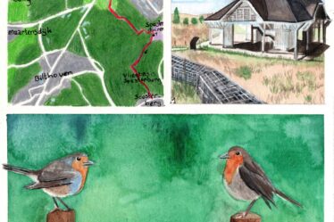
First I walk through the centre of Oosterhout and then past the monastery to the outskirts. I walk past beautiful farms. Unfortunately, it is plastic collection day and ugly orange containers are everywhere.


I then walk through Oosterhout via a number of parks and green zones. I make a small side trip to the beautiful ruins of Strijen, also called the Slotbosse tower.


I take a photo of the front of the tower, but there are ugly pallets in front of it. I walk all the way around the tower to perhaps get the ruin better in the photo. There, the tower has been photographed from all sides and yet the first photo with pallets is the nicest 🤷🏻♀️.


Then I walk out of Oosterhout through the polder to Geertruidenberg. I walk along a canal and a little later along the Donge river. At a sandbags sculpture (there was once a dike breach here), I should’ve kept walking along the Donge river, but here, too, I have gone the wrong way. I turn right instead of straight ahead. I really thought the arrow pointed to the right.


Via the outskirts of Raamsdonksveer, I still reach the fortified town of Geertruidenberg, with the Amer power plant’s cooling tower constantly visible on the horizon.


Fortified town Geertruidenberg today falls under the province of North Brabant, but it has not always been so. In 1213, Geertruidenberg was the first to receive city rights from the Earldom of Holland. The first fortifications came during the 80-year War. Later, the city was improved and expanded by Menno van Coehoorn. Since the time of Napoleon, the city belongs to the province of North Brabant.
Many historic buildings have been preserved, including the Arsenal, the Main Guard, the Market Barracks, the Fish Hall and City Hall.
Sources (in Dutch): Zuiderwaterlinie en Wikipedia
The trail goes a bit over the fortified walls of Geertruidenberg. I see a family of swans in the canal and two Nile geese have a nice vantage point from a cannon 😂.


I walk past some landmarks on the Commander’s stronghold. An information panel tells more about this place.


I continue towards the Market Square to take photos of the Church of St. Gertrude, but unfortunately there turns out to be a fun fair. So no nice photos of the church from afar. Up close, I do manage to get photos of the church without the fun fair rides. I walk a full circle around the church and pass the Vismarkt. Next time, I will start very early for nice photos after all.


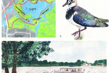
Part 2: Geertruidenberg – Waspik
After a few weeks, I arrive in Geertruidenberg very early in the morning. It is still dark even. I walk a self-made trail through and around the fortified town. On the Market Square, the two well-known towers of Geertruidenberg are to visible: the tower of the Church of St. Gertrude and, with a 180º turn, also the cooling tower of the Amer power plant.


As it starts to get lighter, a beautiful veil of mist covers the landscape. Then once more towards the Market Square where the Church of St. Gertrude looks beautiful in the soft blue light.


Via the Koestraat and a large bridge over the water, I continue the trail towards Raamsdonksveer. I hike straight through Raamsdonksveer and walk at a fast pace, as it is busy with people going to work or school.
Other trail guide about the same region
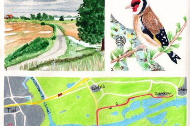
At a highway, I turn left and look out over the misty fields. The mist causes steam to pour from the haystacks along the road. Finally it is quiet on a nice path along the water, again the Donge river.


The skyline of Raamsdonk is visible in the distance. The St. Bavo church forms the landmark. I walk through Raamsdonk and pass the former station building with name on the facade. The station was once one of the stops of the so-called Halvezolen (half sole) train track.


The Half-sole track was a railway line that ran from Lage Zwaluwe via Waalwijk to ‘s-Hertogenbosch in the Netherlands. The name of the railway refers to the supplies that were transported via train to shoe factories in the region. Half sole also means a silly person in Dutch.
Several station buildings are still preserved, such as the stations of Zevenbergschenhoek and Raamsdonk. The photogenic Moerputten bridge near ‘s-Hertogenbosch is also a remnant of this railway track.
Source (in Dutch): Wikipedia
The cycle path towards Waspik follows the former train track of the Half Sole Line. I come across a sculpture that has been created as a reminder of this train track. It is interesting that there used to be a railway track here, but it does make the path a bit boring: a long, straight cycle path.

A while later, I reach the outskirts of Waspik, where I get on the bus back home.
Final thoughts
This time it is not a very extensive story. These were two fine hikes on the Southern waterline trail. For the Slotbosse tower and Geertruidenberg, I would like to return again. For the in-between trail, not necessarily.
The misty morning on the second hike was really enjoyable.
More info:
Trail: Section 7 7 en Section 8 Southern Waterline trailWhere: from Oosterhout to Geertruidenberg and from Geertruidenberg to Waspik, Noord-Brabant, the Netherlands.
No. of km: +/- 12 and 12.5 km
Hiking date: 30 September and 18 October 2022
Materials used in illustrations: Coloured pencils for the map and watercolour paints for the illustrations
Rating: ⭐⭐⭐
Pin this hike
Would you like to do this Fine hike as well? Pin this hike on Pinterest to save for later!

More mysterious misty hikes
It is lovely to hike when there is a blanket of mist over the landscape. You seem alone in the world and it gives everything a mysterious touch. Here below are some more mysterious misty hikes:
ColourFlux Studio makes use of so-called affiliate links. If you buy a product through the link in an advertisement, ColourFlux Studio receives a small amount. There are no additional costs for the buyer.
Back to Blog.